University Forests
The University Forests Office of the University of Maine is responsible for managing the forestlands owned by the University of Maine and the University of Maine Foundation.
The University Forest
The University of Maine and the University of Maine Foundation own a total of 51 properties accounting for approximately 14,436 acres of land throughout the state. The University Forest Office, part of the University of Maine School of Forest Resources, is responsible for the management of all forest properties. For a list and descriptions of the UMaine and UMaine Foundation properties, please click here. The office also coordinates research activities on the land. The forestland under management is comprised of four major parts:
- Dwight B. Demeritt Forest: over 1,800 acres in Old Town and Orono immediately adjacent to the University campus.
- Campus, MAFES, and Outlying Woodlands: approximately 4,091 acres of land owned by the University of Maine and not part of the Dwight B. Demeritt Forest
- Penobscot Experimental Forest: 3587 acres is located approximately 15 miles from the University campus in the towns of Bradley and Eddington.
- Green Endowment Lands: 23 parcels of land accounting for 3,162 acres, donated to the University Foundation for the benefit of the University of Maine.
Click here for more information on University Forest-managed lands.
University of Maine Outlying Forestlands are located across the state of Maine, with management objectives that vary by property and include timber revenue, recreation, preservation of important ecosystems, supporting farm operations, wildlife habitat, research, and education. Five parcels are permanently conserved by working forest conservation easements that prohibit future development but allow timber management and other traditional uses. Properties in Hartland and Georgetown host American chestnut plantations managed by the American Chestnut Society. A Christmas tree seed orchard is in development at the Hartland property in cooperation with the Maine Christmas Tree Growers Association. The Hyland tract in Old Town hosts the Orono Bog Boardwalk, providing access to a domed bog ecosystem. The Perch Pond woodlot provides public access to over two miles of shoreline on Perch Pond and includes many miles of mountain bike trails developed in cooperation with the Penobscot Region chapter of the New England Mountain Bike Association.
By the Numbers
- 4,091 forested acres
- 19 parcels across the state of Maine
- 1,641 acres permanently conserved by conservation easements
- 7 forests associated with experimental farms and field stations
- 2 American chestnut plantations
- 1 domed bog ecosystem of statewide significance
The Green Endowment lands have been donated to the University of Maine Foundation to support the forestry program. Forest lands acquired by the University of Maine Foundation on behalf of the College of Earth, Life, and Health Sciences will be managed under a forestry management plan consistent with the wishes of the donor for the benefit of generations of students to come. Revenue from these lands has enabled the University Forest office to continue to employ students in the forestry program during the school year and over the summer. Students who work with University Forest licensed foresters at a variety of tasks including logging, precommercial thinning, property
line maintenance and forest inventory gain valuable work experience that supplements their formal course work. The University of Maine Foundation continues to accept do- nations of forestland in support of the Green Endowment. More information about the green endowment can be found at https://umainefoundation.org/types-of-gifts/green-endowment
By the Numbers
- 3162 Acres
- 23 Properties
- 50 University Students Supported in the Last 10 years
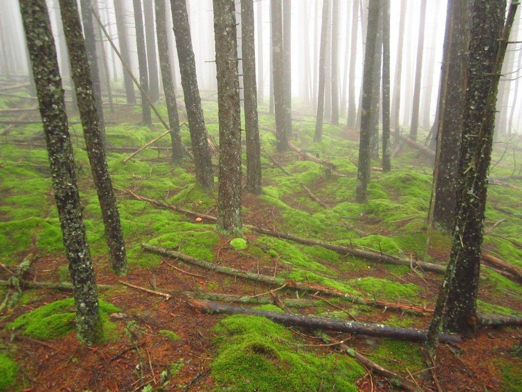
The Dwight B. Demeritt Forest is located adjacent to the University of Maine’s flagship campus in Orono and Old Town. The forest has been under the management of the University Forest Office since 1939, it is managed for a sustainable sup- ply of timber to fund operations. The Demeritt Forest serves as a living laboratory for University of Maine students who will become the future stewards of the natural resources of Maine, the United States and beyond. Forestry and wildlife researchers explore issues of concern to Maine’s forests, from how tick populations respond to forest harvesting to how trees respond to drought in a changing climate. University and local community members enjoy the network of trails and roads for activities such as cross country skiing trails and mountain biking. Local school districts use the forest extensively as an outdoor classroom learning space for students of all grade levels.
By the Numbers
- 1,865 acres of forestland
- 36 courses use the forest as a living laboratory
- 16 miles of trails open to public recreation
- 1.9 million board feet of white pine sawtimber sustainably harvested over the past 25 years
- 450 trees tapped for maple syrup
- 85+ years under professional forest management
The PEF is located in central Maine in the towns of Bradly and Eddington. It was established in 1950 by a group of seven large timberland owners and leased to the United States Forest Service to study spruce/fir silviculture. The PEF is part of a nationwide network of USFS experimental forests. Seventy-five years on, the forest is now owned by the University of Maine Foundation, a 501c3 nonprofit. It is the only privately owned USFS experimental forest. The 1,000-acre USFS compartment study is ongoing and has maintained the core focus of studying the silviculture of Acadian Forest Northern Conifers. Seventy-five years of continuous inventory plot data from the study are available online. The range of research questions addressed at the PEF has evolved and greatly expanded since its establishment to keep pace with new challenges and questions. Recent areas of research include:
- Carbon storage and sequestration
in northern conifer forests - Climate adaptive forestry
- Small mammal personality and its
effect on forest stand dynamics - Northern white cedar silviculture
and ecology - Rehabilitation of degraded forest
stands
By the Numbers
- 3,855 acres of forestland
- 75 years of continuous data from a USFS silviculture study
- 1,559 acres of active research projects
- 1 full in-state scholarship funded from forest revenue
- 603 acres of wetland ecosystems
- 1 million+ river herring return to Blackman Stream each spring